
This project has been funded with support from the European Commission.
This web site reflects the views only of the author, and the Commission cannot be held responsible for any use which may be made of the information contained therein.
This project has been funded with support from the European Commission.
This web site reflects the views only of the author, and the Commission cannot be held responsible for any use which may be made of the information contained therein.
Homepage > Learning Science through Nature > Geographical Areas
GEOGRAPHICAL AREAS
PICTURES
 |
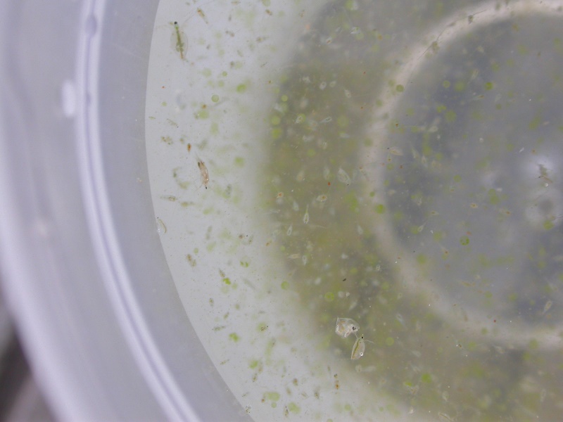
Biological analysis of the aquatic environment | The periodic monitoring of aquatic ecosystems is crucial for obtaining information to prevent their degradation. The physicochemical analyses are important but they are not sufficient to determine the good ecological state of the reservoirs: They are like a photo of the reservoir - giving a static image... Thus, populations of organisms (plankton, fish) are also monitored - these are refined sensors of environmental changes and reflect, better than any technological sensor, changes in water quality - they are like a film: they give a dynamic image of the aquatic system in question ... After some time, we may not detect the contamination or pollutants if we only have physicochemical data, but when we analyze the populations of bioindicator organisms, we can know that something happened even if the chemical contamination is no longer detectable. In this figure we present a vertical trawl used to collect zooplankton samples. This particular net has a mesh size of 64 μm. |
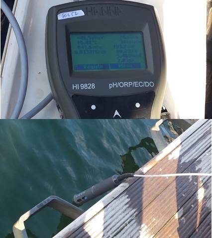 |
Physicochemical analysis | The information gathered from the determination of the physicochemical parameters, along with the information given by the analysis of aquatic communities, is an important contribution to a holistic understanding of the ecological status of aquatic ecosystems. The determination of some parameters is done in-situ, that is, at the site itself. It is the case of the measurement of water temperature, dissolved oxygen concentration, conductivity and pH. For the determination of these parameters, multiparameter probes are used as shown in the figure. Other parameters such as the concentration of the different forms of phosphorus and nitrogen nutrients (important to realize the degree of eutrophication of the aquatic ecosystem under study) are determined ex-situ, i.e., in the laboratory. |
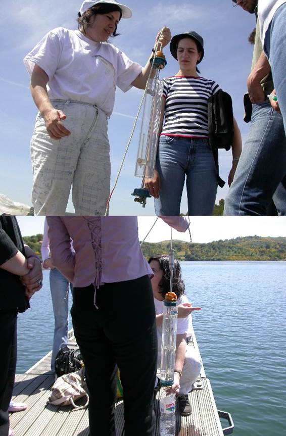 |
Collection of the water sample | In order to collect a water sample for the determination of physicochemical parameters or to sample phytoplankton communities it may be necessary to take several samples at various points of the reservoir and at different depths. In-depth sampling is particularly relevant when the reservoir is stratified. For example, the investigation may require taking samples from the topmost layer (epilimnion), the intermediate layers (metalimnion), and finally one or more samples from the deeper layers (hypolimonion). At the deepest points it is common for a reservoir to be about 50 m depth. So the question that arises is: \\\"How to collect water samples at a 50 m depth?” It seems impossible, but it is not. When researchers want to collect a sample of water at a given depth in the water column it is possible to use simple equipment like a Kemmerer Bottle that opens from both sides. The open bottle is lowered to the desired depth through a cable. As soon as it reaches the thrown depth, the bottle is closed by a weight (called the messenger) which is launched through the cable from the surface. |
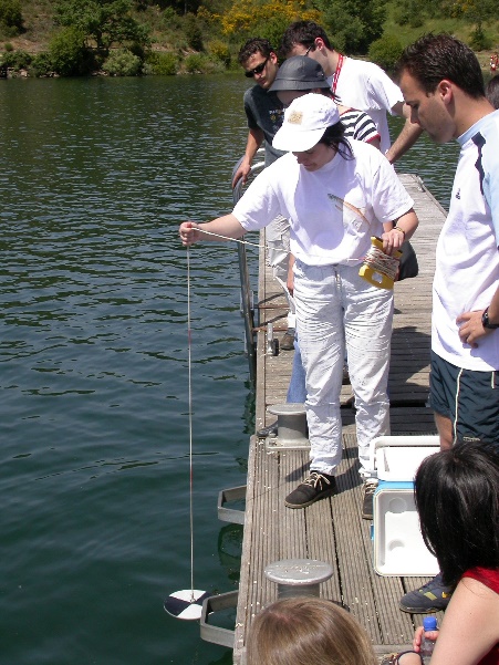 |
Water transparency: the Secchi disk | The Secchi disc (SD) was invented by the Italian priest Pietro Angelo Secchi around 1865. The transparency value of SD is a function of light reflection by its surface and is therefore influenced by the absorption characteristics of water and existing organic matter, suspended or dissolved. The determination of water transparency in lakes and reservoirs with this instrument is summarized as follows: (1) at the selected location the Secchi disk is sunk on the shadow side of the boat; (2) the disc is continuously sunk until it complete disappears; (3) after registering the depth of disappearance of the disk (depth 1), it should be sunk a bit more; (4) later, the disk is lifted until its complete visualization (depth 2); (5) the depth of the visual disappearance of the Secchi disk (water transparency) is equal to the mean value of depths 1 and 2. Currently, the SD used in inland waters has a diameter of 20 cm and continues to be widely used due to its simplicity, low cost, ease of transportation and the information it can provide on the trophic state of the lake or reservoir. The calculation of the depth of the euphotic zone is determined by multiplying the SD depth by 2.709. |
 |
The importance of zooplankton | Organisms, usually microscopic, that float erratically in the water column are considered to be part of Plankton. Photosynthetic organisms (producers) such as microalgae and cyanobacteria are considered Phytoplankton. Zooplankton encompasses animals (consumers). The animals that are considered as truly planktonic are distributed by three large groups: class Rotifera and by two sub-classes of the Crustacea: Cladocera and Copepoda. Zooplankton plays a key role in lakes and reservoirs because of the interactions it establishes with lower and higher levels of food webs The herbivores that are part of the zooplankton, besides controlling the populations of microalgae and serve as food for fish, also condition the concentrations of nutrients and organic matter, influencing their sedimentation rates. The characteristics of zooplankton communities associated with their sensitivity and rapid response to environmental variations make them good sentinels of possible changes in water quality and ecological integrity of lakes and reservoirs. |
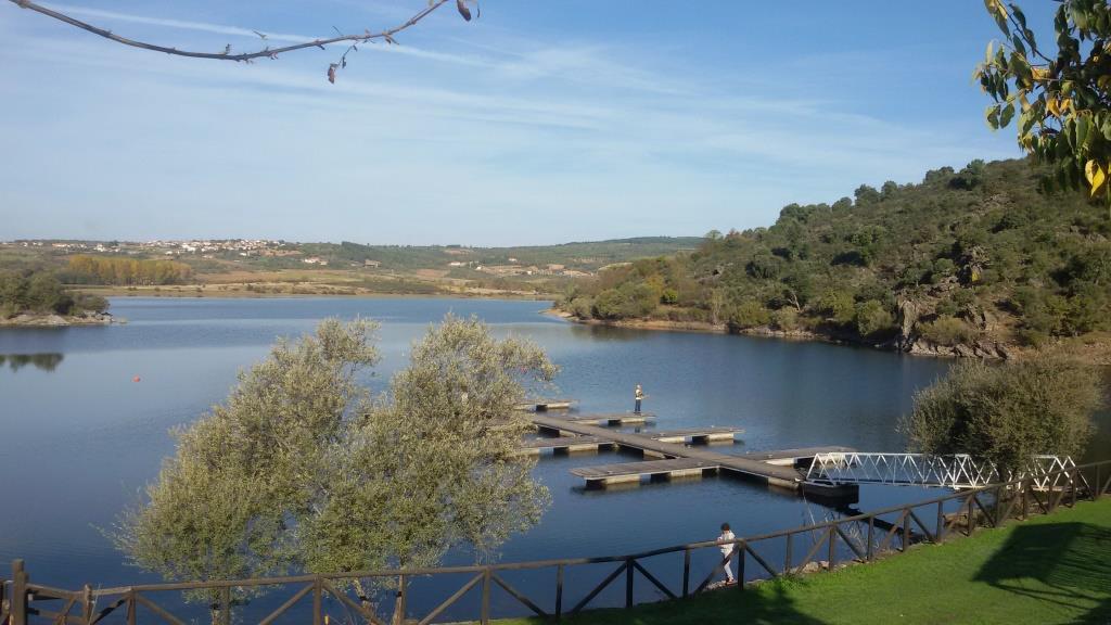 |
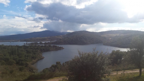
Monitoring water reservoirs | Almost 200 large reservoirs exist in Portugal, serving not only for the production of electricity but also for other purposes such as irrigation, urban supply and tourism. The Azibo reservoir is essentially used for urban supply and tourism. The main causes of degradation of the water quality and the ecological integrity of these aquatic systems are the bad agriculture, forestry and urban practices and the extreme fluctuations in the water level. Thus, in a time when water resources are increasingly scarce, not only due to increasing consumption but also to deterioration of water quality, it is urgent to take measures to maintain/restore the good ecological status of these systems. |
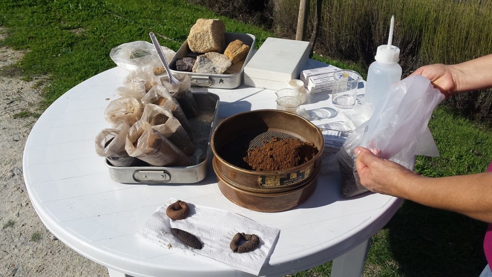 |
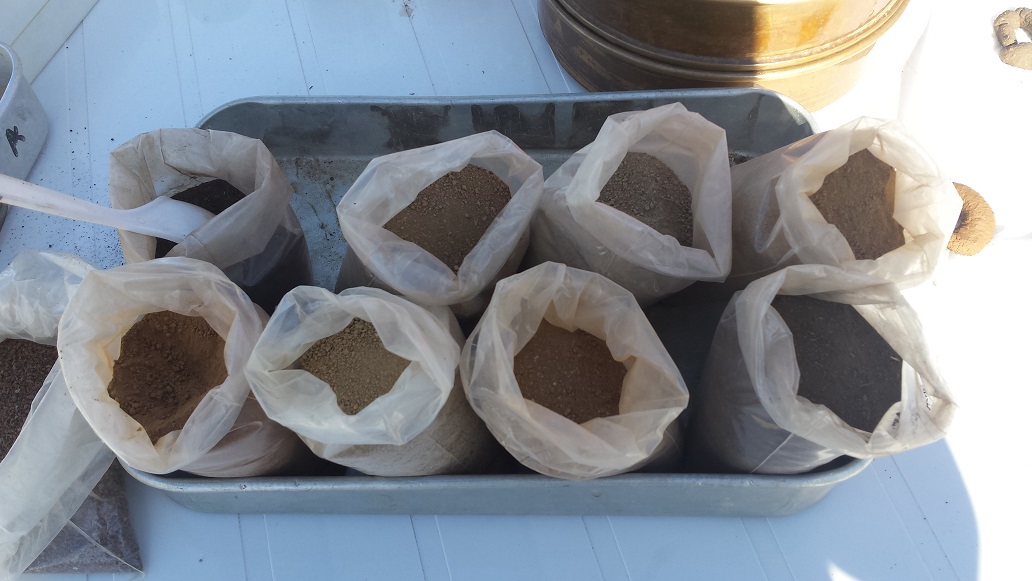
Soil Texture | The soil texture is defined by the relative proportion of sand, silt and clay. It is a property related with parent material. This picture shows different parent materials (rocks in the container A) that give different soil types (little bags in the second container). It also shows a sieve 2mm mesh to separate the fine earth. In foreground, we can see manual soil texture evaluation after hand soil manipulation. |
 |
Soil Color | This picture shows soils with different colors. The soil color is the consequence of a series of factors and processes. Factors are related with the parent material, the organic matter content and the environmental conditions (temperature and humidity). The last are determinant to the occurrence of soil chemical processes. A dark soil has, in general, a high content of organic matter; soils formed from light rocks have clear colors; The presence of iron in the oxidized form imparts reddish or brownish colorations, but in the reduced form (wet soils) it gives blue or grayish colors. |
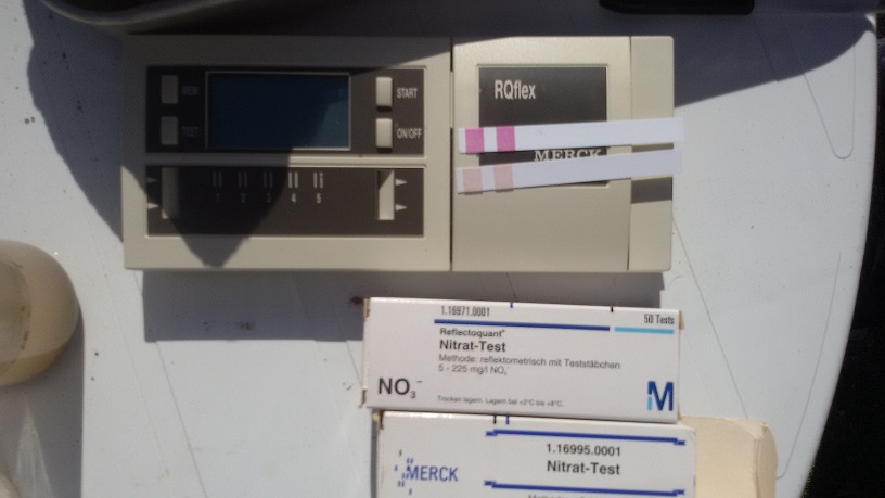 |
Fast tests for the quality assessment of soil | The soil quality is defined by its physical, chemical and biological characteristics. Although these properties are evaluated in the laboratory, portable equipment is available on the market, which uses specific test strips, to allow a rapid evaluation of a parameter in the soil. Its use allows making faster decisions. The excess of nitrates, caused by a high amount of fertilizers, can cause water contamination. The figure shows the results of the analysis of extracts of soils using this type of equipment. The more intense pink color indicates a higher concentration of nitrates. |
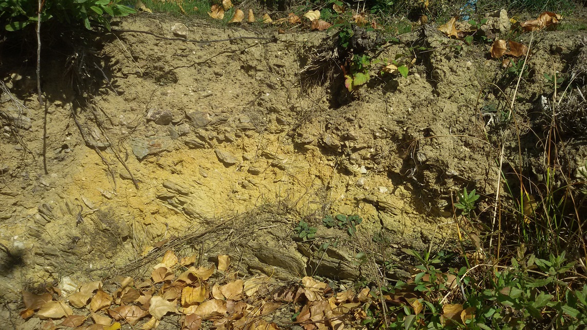 |
Soil Profile | The soil profile is a vertical cut, showing its layers or horizons that can be described from the surface to the parent rock. A horizon is a layer more or less parallel to the surface of the earth, with distinct physical, chemical and biological characteristics of other adjacent ones. The horizon formation depends on the influence of climatic factors on the parent rock; it is influenced by the topography and the action of organisms, during a certain period of time. The figure shows a soil profile consisting of a darker surface horizon, followed by another representing the altering rock. |